Round Dhaulagiri Trek-20 Days

Round Dhaulagiri Trek-20 Days

Starting From

Kathmandu

Ending at

Kathmandu

Duration

Accommodation

Hotel, Lodges and Tent

Trip Grade

Strenuous

Max. Altitude

5360m

Meal Plan

Break-fast,Lunch and Diner

Group size

2-15

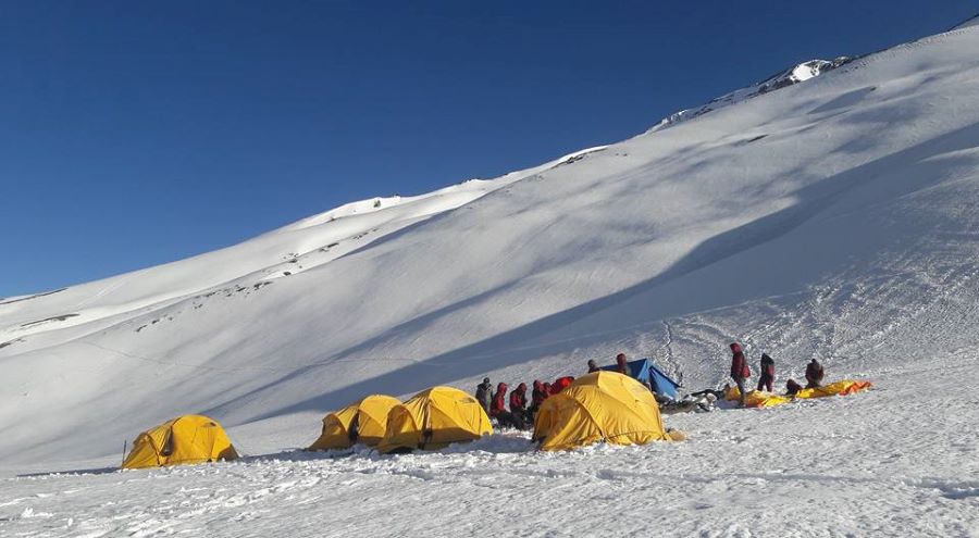
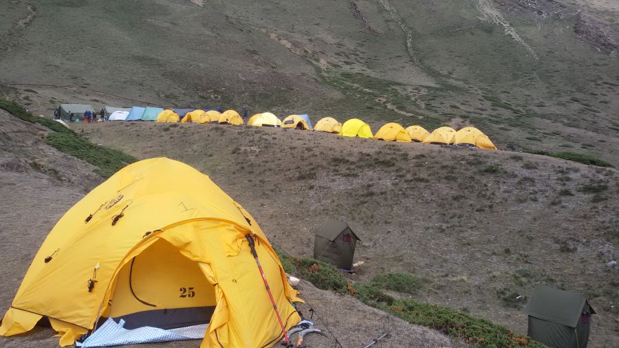
Dhaulagiri Circuit Trek is an adventurous and difficult trek that takes you thru some lovely glaciers and excessive snow-clad passes to the Dhaulagiri Base Camp which would possibly likely be a dream of any journey lover. however, proudly owning to its difficult terrain, secluded and stale crushed trail and lack of proper accommodation facility, this trek is appropriate handiest for the ones match guests with high staying power capacity.

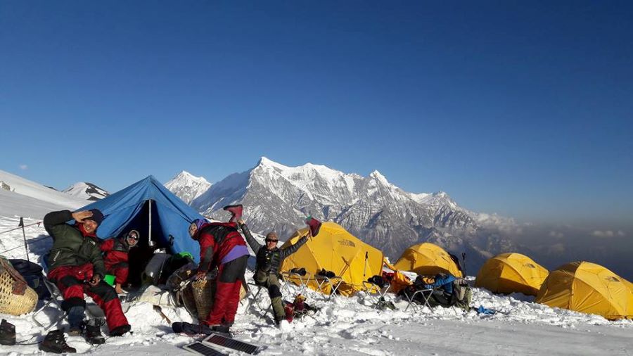
the beautiful mountain  Dhaulagiri that rises at 8167m  is the 6th highest mountain on the planet. The trek that initiates from a small and popular metropolis that lies at the confluence of Myagdi River and Kali Gandaki gorge and takes you to some unspoiled and much less travelled regions which have been capable of keeping its herbal beauty and splendour intact. the lush panorama, hidden valleys, high mountain passes alongside many snow-capped peaks like Mt. Dhaulagiri, Mt. Manaslu, Mt. Annapurna and different peaks is a natural boon that makes Dhaulagiri trek a herbal paradise.

Dhaulagiri Circuit Trek is the trophy of crossing two excessive mountain high passes, French pass at 5,360m and Dhampus pass at 5,234 m. The trek is not just about high mountain passes and snow-clad peaks however the richness in flowers and faunas is a treasure that it holds within its jungle, hills, and unspoiled agricultural lands. The people that live in this remote location are thought in themselves. The lifestyle they live and the precise subculture that they've been treasuring since lengthy is beautiful and cute.

Trek being from Beni in which you initiate your actual trekking adventure. You pass the warm and vibrant villages of Darbang, Muri, and Chariban to the Italian camp and Dhaulagiri Base camp. at the path, you pass the excessive-high mountain passes like French pass and Dhampus pass from in which you descend down to the Marpha and be a part of the Annapurna Circuit route. Dhaulagiri Circuit Trek is the most loved trekking path but because of its remoteness and certain standards to be a successful trekker.

Why the Dhaulagiri Circuit Trek?

  • For an ‘expedition feel’, due to the remote and rugged nature of the trek.
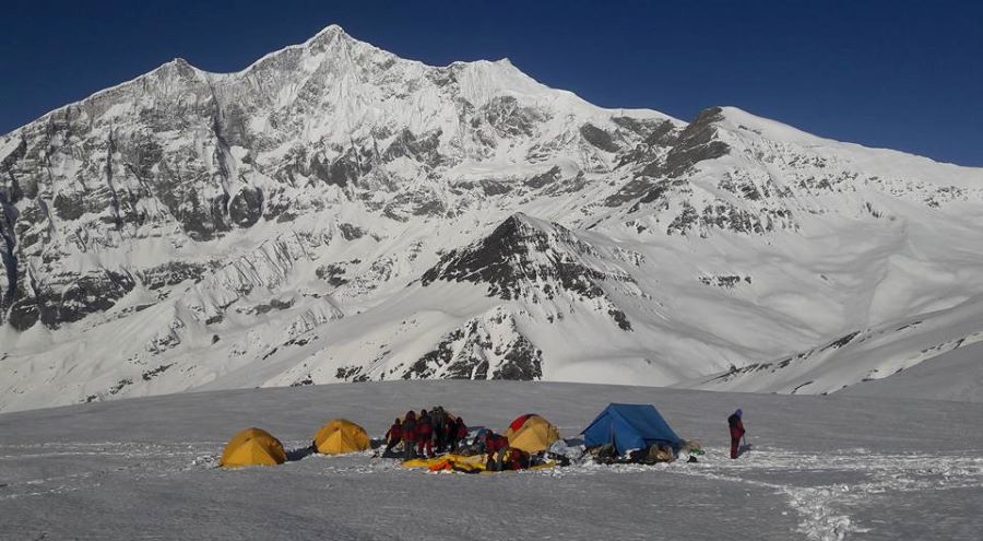
  • Varied landscapes, from green farming villages to snowy glaciers to barren, rocky mountain vistas.
  • The option for experienced mountaineers to climb Dhampus Peak (6,060 m).
  • Close-up views of Dhaulagiri (8,167 m) and several other 7000 m-plus peaks.
  • As a circuit trek, there is no retracing of your footsteps in the second half.

Best season

Spring (March-May) and autumn (September-November) trekking seasons.

01

Arrival in Kathmandu (1,350m) and transfer to the hotel

Upon your arrival at Kathmandu airport, one of our representatives will greet you and will transfer you to the hotel. Welcome Evening dinner at authentic Nepalese restaurant with cultural performance. Airport pickup by private Car, Van or Bus (According to group size) Tribhuvan International Airport (KTM), Kathmandu, Bagmati, Nepal.

02

Kathmandu Valley Sightseeing and preparation day

Today we are going to visit four of the UNESCO world heritage listed sites in Kathmandu Valley. After breakfast, we start for Kathmandu valley city tour which includes the UNESCO heritage site in the City valley. Pashupatinath Temple is one of the most sacred pilgrims’ sites for Hindus all over the world and It is the temple of Lord Shiva, the temple where the dead bodies are criminated on the Bagmati River. Boudhanath Stupa is one of the biggest stupas in Asia and holiest Buddhist Pilgrims and famous tourist destination in City Valley and It is also famous for over 50 Tibetan gompas or monasteries. Kathmandu Durbar Square holds the places of the ancient king palace who ruled over the Kathmandu Kingdom. Swayambhunath(Monkey Temple) is located in the heart of the City valley and It is another famous tourist destination and holiest Buddhist pilgrims in Kathmandu Valley.

03

Drive from Kathmandu – Beni (1,000m,9h)

We will be heading towards Beni which is also the starting point for our trek. We need to drive on Prithivi Highway from Kathmandu. The drive will last for about 9 hours. The drive will be long but the views along the highway are beautiful and will pass through the famous lake city of Pokhara. Overnight at teahouse

04

Drive:Beni – Dharapani (1560m,6h)

We will move towards Darbang. From Darbang we will walk about 3-4 hours to reach Dharapani. Following the river(Myagdi Khola). On the way, we will see Dhaulagiri range, Gorje himal. We will cross Magar and Gurung village. Overnight camping. Walking duration: 6 Hours Cumulative Ascend Value: 783 m Cumulative Descend Value: 145 m

05

Dharapani – Muri (1850m,6h)

After crossing the river to its West Bank as you leave Phedi, the trail starts climbing in earnest and there will be many switch-backs until you arrive at the ridge and the angle of ascent eases. Again the trail climbs steeply to the villages of Muri. Continue your trek to Sibang and Mattim. From here you continue up an incline to the snout of the ridge, descend to the Gatti Khola and reach Phalai Gaon (1,810m). Cross the Dhara Khola to once again emerge on the west bank of the Myagdi Khola and then climb a ridge to the large Magar village of Muri.Overnight camping. Walking duration: 6 Hours Cumulative Ascend Value: 693 m Cumulative Descend Value: 396 m Overnight at teahouse

06

Muri – Bagar (2080m,6h)

Starting from Muri it will take us about 6 hours to reach the Baghara. Today we will be crossing a river called Dhora Khola. Alongside Dhora Khola notice terrace farmlands. From here we will climb the mountain right to us until we reach Ghorban Dhara. Ghorban Dhara provides the perfect view of Ghustung south which is elevated at 6465m. We will then start following the path alongside Myagdi Khola until we reach Naura. We will climb right up the mountainside to Ghorban Dhara. From Ghorban Dhara, we will get to see Ghustung South (6465m). Before reaching the Naura we follow the riverbank path of Myagdi Khola. From Naura, we ascend begins on the mountainside. Sometimes of uphill climbing, and a path that traverses the steep grass-covered hills. And trailing further away in a well-constructed zigzag stone steep paths while descending through a forested area, emerging to a ridge snout Bagar becomes visible elevate at 2050m. Overnight camping. Walking duration: 6 Hours Cumulative Ascend Value: 1039 m Cumulative Descend Value: 795 m

07

Bagar – Dobang (2545m,5h)

The trail first descends through terraced fields to a small ridge, then through a forest to Jyardan which is the most remote permanent settlement in this part. After the settlement, a high winding path crosses a rocky area which then descends before climbing again to Lipshe where there is one single hut. The trail continues through a forest to Lapche Kharka and then climbs to the level area at Dobang. Dobang is a largish clearing in the forest with two huts and a large area for camp. Overnight camping. Walking duration: 5 Hours Cumulative Ascend Value: 892 m Cumulative Descend Value: 503 m

08

Dobang – Sallaghari (3445m,6h)

The trail continues through the dense, lush vegetation of ferns, bamboo and rhododendrons. We cross to the east bank of the Myagdi Khola on a new cantilever bridge and then camp at a clearing in the forest at Sallaghari. Overnight camping. Walking duration: 6 Hours Cumulative Ascend Value: 680 m Cumulative Descend Value: 130 m

09

Sallaghari – Italian BC (3660m,4h)

From Sallaghari we walk through Pine trees, Rhododendron, Birch, once above the tree line heather, juniper and azaleas. The trail traverses through forest and then climbs to a grassy area on the lateral moraine where Italian Base Camp is located. High above camp is the impressive west face of Dhaulagiri with Tsaurabong Peak visible on the other side of the valley. Overnight camping. Walking duration: 4 Hours Cumulative Ascend Value: 1310 m Cumulative Descend Value: 230 m

10

Rest Day for Acclimatization.

Today we can go for a walk to explore the Italian Base Camp or relax in camp. This day is essential for acclimatisation before ascending further in altitude towards main Dhaulagiri Base Camp. Overnight camping.

11

Upper Vungini (Italian BC) – Japanese BC (3890m,5h)

Today is a shorter walk although essential for acclimatization process, unlike most other itineraries we believe in having two nights at Glacier Camp located between Italian Base Camp and main Dhaulagiri Base Camp (otherwise going from 3,660m to 4,740m will result in altitude sickness). From Italian Base Camp, the trail descends steeply down the lateral moraine to gain the glacier, in the past, we have fixed a rope here to help the group and trek crew. We cross the glacier and then traverse along the moraine on the left side of the Chonbarden gorge. We walk along talus in the impressively narrow Chonbarden gorge to the snout of the Chonbarden glacier and then continue for another hour to Glacier camp. There are a number of ledges levelled in the ice of the glacier for our tents. Overnight camping. Walking duration: 5 Hours Cumulative Ascend Value: 695 m Cumulative Descend Value: 124 m

12

Japanese BC – Dhaulagiri BC(4748m,5h)

We follow a rough trail along the moraine covered glacier to Dhaulagiri Base Camp. From Base Camp the view is impressive with Dhaulagiri I, Tukuche Peak and Little Eiger and further to the west lay Dhaulagiri II (7,751m) and IV (7,618m). One can also see the start of the climbing route through the icefall. In season there are likely to be expeditions camped on the moraine strip at Base Camp. Overnight camping. Walking duration: 5 Hours Cumulative Ascend Value: 495 m Cumulative Descend Value: 43 m

13

Dhaulagiri BC – French Col(5360m) – Hidden Valley (5140m,7h)

After an early breakfast, we walk out of Base Camp along the moraine strip to cross over to the left-hand side of the Upper Chonbarden glacier. A high lateral moraine ridge is visible further up the valley; we gain this by following a steep trail across the screen and talus. Once on the lateral moraine ridge there are superb views back down the valley to Dhaulagiri I and Tukuche Peak. At a large cairn on the lateral moraine ridge, we turn off to make the final ascent to French pass . The approach to the pass is up easy angled snow slopes and as usual in Nepal, the top is marked by Buddhist prayer flags and cairns. The view from the summit of the pass is superb with Sita Chuchura, the peaks of the Mukut Himal, Tashi Kang, Tukuche Peak and of course Dhaulagiri I. The descent from the pass is on moderate snow slopes as we enter Hidden Valley. After a long descent, you arrive at camp next to the river not far from the base of Dhampus Peak. You will notice once crossing into Hidden Valley there is only sparse vegetation of isolated patches of moss and grass as this area is now in an area affected by the rain shadow effect of Dhaulagiri. Overnight camping. Walking duration: 7 Hours Cumulative Ascend Value: 690 m Cumulative Descend Value: 223 m

14

Hidden Valley – Cross Thapa Pass (5244m) – Kalo Pani (5100m,7h)

This is a long day and by far the toughest on Dhaulagiri Circuit trek. After an early start from camp, we start the climb up a moderate snow slope to gain Dhampus pass. There are fine views of Dhampus Peak to the left of the pass and to the right the beautiful ice flutings of Tukuche Peak. From the summit of the pass, the trail descends pass for about 100m before start to traverse left into Kali Gandaki valley. Depending on the snow and ice conditions crampons may be needed for group & porters at this point. There is a very long traverse on snow usually taking about four hours before starting the steep descent to Kalo pani. Throughout this traverse, there are stunning views of Nilgiri and the western end of the Annapurna Massif. Overnight camping. Walking duration: 7 Hours Cumulative Ascend Value: 164 m Cumulative Descend Value: 314m

15

Kalo Pani – Marpha (2670m,5h)

There is a very long traverse on snow usually taking about five hours before starting the steep descent to Kalo pani. Throughout this traverse, there are stunning views of Nilgiri and the western end of the Annapurna Massif. There is a long descent today to the village of Marpha located in the Kali Gandaki valley. Marpha village has a Buddhist monastery, Tibetan whitewashed houses and paved streets. It is also famous for its apple orchards so well worth stopping here to get a glass of apple juice at one of the lodges. Overnight in Marpha. Walking duration: 5 Hours Cumulative Ascend Value: 1082 m Cumulative Descend Value: 2332 m

16

Marpha – Jomsom (2710m,3h)

Jomsom is the best place in town located opposite the airport. After hot showers you can explore Jomsom, check emails than in the evening the cooks will produce a special last meal together. Later on, we will hand out tips to our crew as a thank you for all their hard work throughout the trek. Overnight: teahouse lodge. Walking duration: 3 Hours Cumulative Ascend Value: 50 m Cumulative Descend Value: 1233 m

17

Fly:Jomsom – Pokhara (35min)

Early morning we will take a short picturesque flight to Pokhara. The view of Annapurna and Dhaulagiri mountains and the world’s deepest gorge, Kali Gandaki is stunning. Relax whole day in Hotel or wander around Lake Side with fascinating mountains panorama view and nature charming. Explore the various interesting places like Mahendra Cave, David’s fall and the various lakes of course.

18

Drive: Pokhara – Kathmandu (7h)

After breakfast, we leave the beautiful lake city of Pokhara and drive towards Kathmandu. After reaching Kathmandu, we have the rest of the day off to rest or do some souvenir shopping.

19

Free day in Kathmandu

Free day for shopping and other activities in Kathmandu.

20

Final Departure

Our representative transfers you to the Kathmandu airport to catch your returning flight back home. Thank you for Travelling with Churen Himal Treks and Tours. Airport drop by private Car, Van or Bus (According to group size) Tribhuvan International Airport (KTM), Kathmandu, Bagmati, Nepal.

The cost includes

1. Airport pick up and drop (both international and domestic)
2. 4-night hotel in Kathmandu with BB
3: Fresh Meals on full board ( Breakfast + Lunch + Dinner) with hot drinks and Tea/ Coffee
4: Trekking Information Management System ( TIMS)  Card and ACAP Fee.
5: Transportation cost for our trekking crew
6: Guided sightseeing tour in Kathmandu
7: Domestic flight with the airport tax
8: All wages, equipment, food, medical and accident insurances for all involved staff in trekking
9: An English speaking Local Expert trekking guide, assistant guide, cook & necessary porters
10: Our service charge and government taxes levied in Nepal
11: Churen Himal Treks baggage or T-shirt
12: First aid medical kits for the group and the staff
13: Dhaulagiri region trekking Map
14: Welcome dinner in a typical Nepali restaurant with cultural program  in Kathmandu
15.Camping equipment such as tents, kitchen tents, dining tent toilet tent and other required
16.Camping crew such as kitchen boy, cook, helpers etc

17.Arrangement of Emergency Helicopter service which will be paid by your Travel insurance company

The cost excludes

1: Nepal entry visa fee
2: International airfare

3: Entrance fees for sightseeing/monument visit as per the itinerary
4: Lunch and dinner during your stay in Kathmandu and Pokhara (except welcome dinner)
5: Travel insurance which has to cover emergency high-altitude rescue and evacuation compulsory
6: Personal expenses (shopping, snacks, boil bottled water, hot and cold drinks, hot shower, Alcohol, Wi-Fi, telephone call, battery re-charge fee), extra porters etc

7: Extra night accommodation in Kathmandu due to early arrival or late departure, early return from the trek.
8: Clothing packing items or bags, personal medical kit
9: Personal trekking gear ( Down Jacket and Sleeping Bags)
10: Any additional staff other than specified
11: Tips for guide and porters (Recommended by the Culture)
12: In case of natural calamities i.e. change of government policies, strikes, cancellation of flight due to weather, illness, itinerary modifications due to safety concerns, landslides etc the extra charge should be born by themselves.

13: Any other items not mentioned in “The Service Package Excludes” Section

Equipment Check List for Trekking

HEAD

  • Sun hat or scarf
  • Light balaclava or warm fleece hat
  • Sunglasses with UV protection


FEET

  • Thin, lightweight inner socks
  • Thick, warm wool hiking socks
  • Hiking boots with spare laces
  • Camp shoes (sneakers and/or sandals)
  • Gaiters for hiking in winter


HANDS

  • Lightweight gloves
  • Heavyweight gloves or mittens
  • With a waterproof shell outer (Seasonal


LOWER BODY

  • Under Garments
  • Hiking shorts
  • Lightweight cotton long pants
  • Light and expedition weight thermal bottoms
  • Fleece or wool pants (seasonal)
  • Waterproof (preferably breathable fabric) shell pants


UPPER BODY

  • T-shirts
  • Light and expedition weight thermal tops
  • Fleece jacket or pullover
  • Fleece Wind-Stopper jacket (Optional)
  • Waterproof (preferably breathable fabric) shell jacket


ACCESSORIES

  • Sleeping bag rated to zero degrees F *
  • Headlamp (e.g. Petzl Zoom) with spare bulbs and batteries
  • A small pad or combination lock-to-lock
  • Trekking Bags/Duffel bag
  • Basic First Aid Kit
  • Large plastic bags – for keeping Items dry inside trek bag
  • Day pack (Approximately 20-22 Liter)
  • Trekking Poles
  • Water bottles
  • Toiletries (Small wash towel, Toilet papers etc)
  • Ear Plug (who know some people on group are snoring)


TOILETRIES

  • Toothbrush/paste
  • Multipurpose soap
  • Nail cutter
  • Small mirror


Personal Hygiene:

  • Wet wipes (baby wipes)
  • Tissue /toilet roll
  • Anti-bacterial hands wash


EXTRAS/LUXURIES

  • Binoculars
  • Reading book
  • Trail Map/Guide book
  • Journal & Pen
  • Pencils and small notebooks
  • Travel game i.e., cards
Click to ask        

Comments

Write a review

Captcha Image

We are affiliated with

Professional Affiliations.
We are registered, affiliated and recognized by the following institutions.