Equipment List:
Climbing Gear
- Helmet: Must be able to fit over your ski hat
- Alpine Ice Axe: General mountaineering tool (65-70cm)
- Crampons: 12 points
- Ascender: 1 right or left-hand ascender
- A mountaineering harness, with adjustable leg loops
- Carabiners: 3 lockings and 6 regular*
- Rappel device: ATC or figure 8*
Clothing
Footwear:
- Mountaineering boots: suitable for above 8000m; Scarpa phantom 8000 or equivalent (This is because we can work under extreme weather conditions and also preparing you for your ultimate goal to climb Everest)
- Hiking shoes for the trek to base camp.
- Booties: Optional, down is best.
- Bridgedale Summit socks or equivalent: 6 pairs
- Bridgedale Liner socks or equivalent: 3 pairs
Body Layers:
- 2 merino base layers: top and bottom
- 1 mid-layer top: breathable
- Underwear
- Lightweight Nylon Pants: 1 pair
- Soft Shell jacket with hoody: To be worn over other layers
- Soft Shell Pants: Very breathable and water repellent
- Hard Shell Jacket with hood: A waterproof and breathable shell jacket
- Hard Shell Pants: Waterproof and breathable shell pants
- Insulated Down Jacket with hood: (fill power 800) or equivalent to Rab’s Electron Jacket. We primarily wear this when climbing below Camp 3
- Insulated synthetic Pants: Worn primarily when climbing below Camp 2
- Long jones equivalent to Rab’s Polartec or equivalent: 2 pairs
- Summit Down Suit
Headgear and Handwear:
- Warm Hat: Synthetic or wool hat (ski hat)
- Sunhat: To shade your face/neck from the sun on a hot day
- Buff: To protect your neck/face from the sun
- Glacier glasses: Full protection with side covers or wrap around
- Ski goggles: To be worn on summit day in the event of high winds
- Lightweight synthetic liner gloves: For wearing on a hot day; 2 pairs
- Softshell gloves: To wear for moderate cold/wind
- Shell glove with insulated liner: To wear for severe cold / strong wind
- Expedition Mitts
Personal Gear:
- Expedition Backpack: 65L pack should be large enough.
- Trekking Backpack: To carry on the trek to base camp. Simple and light.
- Sleeping Bag (for high camps): Rated to at least -40°F. Goose down or synthetic.
- Sleeping Bag (for base camp): rated to at least -20°F
- Compression stuff sacks: 3 large ones; for reducing the volume of the sleeping bag, down parka, etc., in your pack
- High-Quality sleeping pad (1 for base camp and 1 for high camps): Full length is preferred
- Closed-cell foam pad: To be used in conjunction with the inflating pad for warmth and comfort when sleeping
- Trekking poles with snow baskets: Adjustable poles
- Cup: Plastic insulated cup for drinking
- Bowl: A plastic bowl for eating dinner or breakfast
- Spoon: Plastic spoon
- Head torch: 1 normal for base camp and 1 with remote battery systems for climbing at night. This will be used whilst climbing at night
- Sunscreen: SPF 50 or above
- Lip balm with sunblock
- Water bottles: 2 wide mouth bottles with a 1-litre capacity
- Water bottle parkas (2): fully insulated with zip opening
- Thermos: 1 litre (buy a good one to keep your water warm for longer hours)
- Pee bottle: 1-litre minimum bottle for convenience at night in the tent
- Toiletry bag: Include toilet paper and hand sanitizer and a small towel
- Hand warmers & toe warmers
- Penknife or multi-tool (optional)
- Camera: bring extra batteries and memory cards.
- Personal solar charging system (optional but recommended)
- Travel Clothes: For days in-country
- Duffel bags (2) with locks: To transport equipment
- Base Camp Items: Kindle, I pad, smartphone, etc
- Snack food: Please bring a few days of your favourite climbing snack food such as bars, gels, nuts, beef jerky, etc. A variety of salty and sweet is good
- Small personal first aid kit: Include athletic tape, Band-Aid’s, Ibuprofen, blister care***, personal medications, etc
- Medications and Prescriptions: Bring antibiotics (Azithromycin, etc.), and altitude medicine such as Diamox and dexamethasone
Mt. Dhaulagiri Expedition (8,167m): Conquer the World’s Seventh-Highest Peak
Introduction
The Mt. Dhaulagiri Expedition offers a thrilling adventure for experienced mountaineers looking to tackle one of the world’s most formidable peaks. Standing at 8,167 meters, Mt. Dhaulagiri is the seventh-highest mountain in the world and is known for its steep terrain and challenging weather conditions. Climbing Dhaulagiri is a test of both physical endurance and technical skill, making it a sought-after goal for serious climbers. If you're aiming to conquer an 8,000-meter peak that combines isolation, beauty, and difficulty, Mt. Dhaulagiri is the perfect challenge.
Where is Mt. Dhaulagiri Located?
Mt. Dhaulagiri is located in the Dhaulagiri Himal range in north-central Nepal. It sits west of the Annapurna range, separated by the Kali Gandaki Gorge, one of the world's deepest gorges. The Dhaulagiri region is known for its rugged landscapes, remote valleys, and rich cultural heritage. Trekkers and climbers alike are captivated by the region’s traditional villages and the pristine beauty of its glaciers and towering peaks.
Why Choose the Mt. Dhaulagiri Expedition?
Climbing Mt. Dhaulagiri offers a unique, less commercialized experience compared to other 8,000-meter peaks such as Everest or Manaslu. Known for its technical difficulty, Dhaulagiri requires mountaineers to navigate steep slopes, treacherous crevasses, and high-altitude challenges, all of which provide an adrenaline-pumping adventure. Additionally, Dhaulagiri remains relatively less crowded, giving climbers a sense of solitude and exclusivity as they traverse its slopes.
Best Time to Climb Mt. Dhaulagiri
The most favorable time to embark on the Mt. Dhaulagiri Expedition is during the spring (April to June) and autumn (September to November) seasons. During these periods, the weather is more stable, offering clear skies and moderate temperatures, especially at high altitudes. Spring is known for warmer weather and melting snow, while autumn provides cooler, crisper conditions with excellent visibility, making the summit views even more spectacular.
Physical and Mental Preparation
Conquering Mt. Dhaulagiri requires intense physical and mental preparation. Due to the technical nature of the climb, climbers should be in excellent physical condition, with strong endurance, cardio fitness, and prior experience with mountaineering at high altitudes. Additionally, mental toughness is vital, as you’ll be facing harsh conditions, altitude sickness, and the pressure of climbing one of the world’s toughest peaks. Regular training, including altitude acclimatization, is highly recommended.
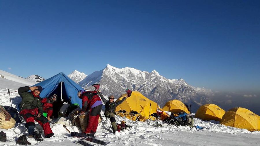
The Route to Dhaulagiri Base Camp
The expedition begins in Pokhara, where climbers drive to Darbang, the starting point of the trek. From there, the trek to Dhaulagiri Base Camp offers stunning views of snow-capped peaks, alpine forests, and remote villages. Trekkers pass through picturesque towns such as Muri and Italian Base Camp, gradually making their way to Dhaulagiri Base Camp at 4,750 meters. The journey to Base Camp is an adventure in itself, allowing climbers to immerse themselves in the beauty of Nepal's wilderness.
Acclimatization on Mt. Dhaulagiri
Proper acclimatization is critical when climbing Mt. Dhaulagiri. Most climbers follow a strategy of rotating between camps, ascending to higher altitudes and then returning to Base Camp to rest. This process, known as acclimatization rotations, helps your body adjust to the reduced oxygen levels at high altitudes, minimizing the risk of altitude sickness and ensuring a safer climb.
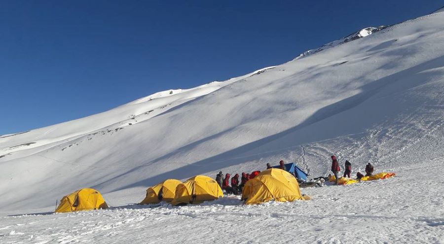
Summit Push: Reaching the Top of Mt. Dhaulagiri
The final summit push is the culmination of weeks of preparation. After acclimatizing and rotating between Camp 1 (5,800m), Camp 2 (6,400m), and Camp 3 (7,250m), climbers begin the summit attempt from Camp 4 (7,500m). The final stretch is incredibly steep and exposed, often requiring fixed ropes and ice axes to traverse the icy slopes. However, the effort is rewarded with breathtaking panoramic views of the Himalayan range, including Annapurna, Manaslu, and even as far as the Tibetan plateau.
Challenges of the Dhaulagiri Expedition
The Mt. Dhaulagiri Expedition is renowned for its technical difficulty and unpredictable weather. Climbers must navigate through steep ice walls, crevasses, and avalanche-prone areas, making this one of the more dangerous 8,000-meter peaks. Strong winds, snowstorms, and the risk of frostbite are constant challenges. The climb is not recommended for beginners; it is best suited for climbers with experience on other high-altitude peaks.
Safety Considerations
Safety is the top priority on any high-altitude expedition. Climbers must always be equipped with proper safety gear, including oxygen tanks, avalanche beacons, and high-quality climbing equipment. Experienced guides and Sherpas are essential for a successful and safe climb. Reputable expedition companies provide experienced leadership, ensuring that all safety protocols are followed and that climbers are well-prepared for the risks involved.
Climbing Gear for Mt. Dhaulagiri
The extreme conditions on Mt. Dhaulagiri require specialized equipment. Essential gear includes high-altitude boots, ice axes, crampons, and fixed ropes. Climbers also need insulated clothing designed for sub-zero temperatures, including down suits, gloves, and goggles. Lightweight but durable tents, sleeping bags rated for extreme cold, and reliable cooking equipment are also necessary to withstand the harsh environment.
Permits and Regulations for the Dhaulagiri Expedition
Climbing Mt. Dhaulagiri requires several permits from the Nepalese government. These include:
- Dhaulagiri Climbing Permit
- Annapurna Conservation Area Permit (ACAP)
- TIMS (Trekkers' Information Management System) Card
These permits are mandatory for all climbers and help fund conservation efforts and maintain safety standards in the region.
Choosing the Right Expedition Company
Selecting the right expedition company is crucial for a successful ascent of Mt. Dhaulagiri. Look for companies with a proven track record, experienced guides, and a strong focus on safety. Your chosen company should offer well-planned itineraries, proper acclimatization schedules, and have access to high-quality equipment. Additionally, make sure your guides have extensive knowledge of the Dhaulagiri route and weather patterns.
The Reward: The Experience of Summiting Mt. Dhaulagiri
Reaching the summit of Mt. Dhaulagiri is a profound achievement. The panoramic views from the top, including the Annapurna range and beyond, are indescribably beautiful. But beyond the views, the sense of personal accomplishment and the mental and physical growth you experience on the journey make this one of the most rewarding climbs in the world.
Conclusion
The Mt. Dhaulagiri Expedition is an exhilarating journey that challenges even the most experienced climbers. From the moment you set foot in the remote valleys of Nepal to the final ascent to one of the world's highest summits, every step of the way is an unforgettable adventure. If you're ready to push your limits and embark on one of the toughest 8,000-meter climbs, Mt. Dhaulagiri awaits.

")